|
| Description of the
Maps
Larger maps listed first. |
Wall
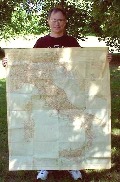
Map of Italy - Large wall map of roads in Italy and includes
Sicily,
Sardinia, Corsica and piece of Tunsia and nothern border
countries.
Map is based on Italian Touring Club Map No 17. Includes names of
towns, routes and mileage and features such as rivers, mountain passes
and topographical details. Prepared by US Army Engineers in 1943.
Color: route numbers, mileage, ocean, mountain features
&
roads.
Size: 40 X 47 inches.
Scale: 1:1,000,000 (1in = 15.8 miles or 1cm = 10km)
Printed on heavy stock.
Dated: 1943.
Tourist
Map of Europe- Consociazione Turistica italiana, Dal Mare
Del
Nord Al Mediterraneo - "Italian Tourist Map From the North
Sea
to the Mediterranean". Large wall map of Europe printed in Milan
in 1939. It includes England, Germany and most of England, Norway
and Sweden, as well north part of Spain and Italy as far down as
Rome.
This map is covered with many names of the towns and regions. The
roads are barely visible. Interesting to see names of countries
and
regions in Italian. Includes names of towns, routes and mileage
and
features such as rivers, mountain passes and topographical
details.
Apparently the owner was plotting the progress of the two armies
closing
in on Berlin.
Color: blue ocean, shaded terrain, red roads. Ink dots
placed
on cities in and around Germany.
Size: 37 X 54 inches.
Scale: 1:500,000 (or 1in = 8 miles or 1cm = 5km)
Printed on light paper---poor condition, torn at folds. Italian
markings
"Dall International Atlas".
Dated: 1939.
Paris
to Rome - Special Air Navigation Chart - A colored contour
map that covers much of Europe including Paris, Caen, Munich, Budapest,
Rome & Naples and part of Sardenia, east coast of Spain and west
coast
of Yugoslavia. Map shows every railroad with legend for 1 & 2
tracks and also mine quarries. No roads. I assume this map
was used for planning tactical bombing missions.
Color: contours in 5 colors. Magnetic navigation compases
printed
in red in 4 places.
Airports are indicated with red circles or red labels.
Size: 34 X 52 inches.
Scale: 1:100,000 (1in = 1.58 miles or 1cm = 1km)
Printed nice paper.
Dated: March 1944 Marked RESTRICTED.
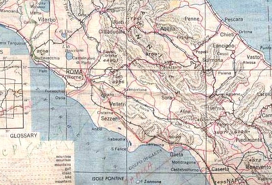
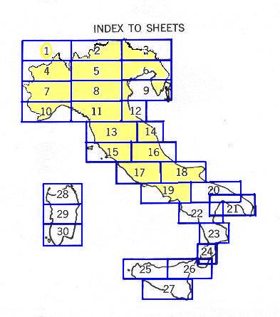
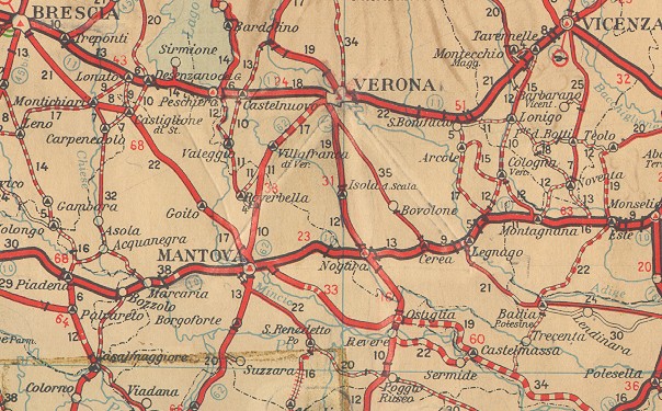
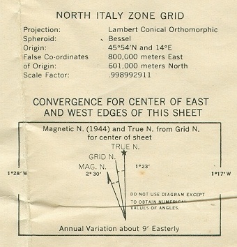
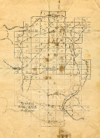
Italy Road Map - A series of 30 maps were made that
cover all of Italy. These maps have shaded topographical
details.
Includes mileage, ID of state roads, elevation of peaks. "A.M.S.
M592 First Edition 1943". See illustration below for an ID guide
for this set.
Color: Blue ocean & roads.
Size 41 X 26 inches(including wide margin along bottom).
Scale 1:200,000 (1 in = 3.16 miles or 1cm = 20km)
Dated: Sept. 1943.
Description
of My Maps See Map ID
guide,
below.
No. 2 - Northern border from Lake Vico & Vitervo to
Piombino,
Grosseto, & Orvieto.
No. 7 - Western border, Turnio(Turni),
Pavia, Alessandria, Alba.
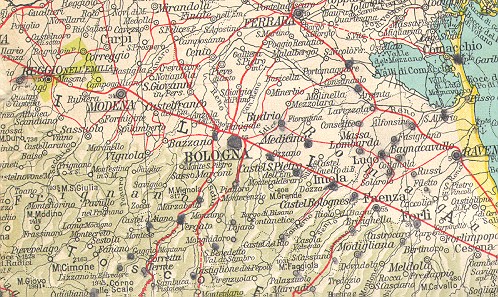
No. 8 - Central Italy: Modena, Ferrara,
Piacenza, Mantova.
No. 9 - East
coast, south of Venice and Istria pennisular.
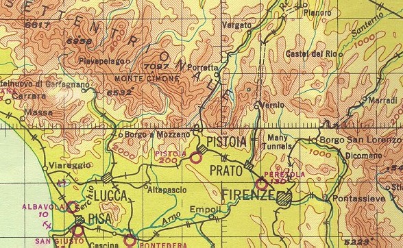
No. 11 - Florence,
Pistoia, Lucca, Bologna & Hiway 9.
No. 12 - East coast, includes Ravenna & Hiway 9 to Rimini
No. 13 - West
coast, Perugia, Firenze, Livorno, Pisa & Arno
River
No. 14 - Fermo, Macerata, Ancona, Fabriano & Fossombrone on
the East coast.
No. 15 - West coast, north of Rome, , Viterbo,
Grosseto.
No. 17 - Rome,
Anzio, Civitavecchia, Cassino.
No. 18 - East Coast & "spur"; Foggia,
Torricella, Vasto, Venafro, S. Bartolommeo.
No. 19 - West coast, South of Rome. Salerno, Naples, Minturno,
Gaeta.
Road Map Sheets
19, 20 & 22 - Salerno area
- This map is the same type as the above Road Maps.
This
large-scale map covers the entire area of the Salerno landings that are
included on portions of Road Maps #19 #20, &
#22. The Salerno area is split between the
different maps so this map combines the area just for Salerno.
Color: Blue ocean & roads.
Size 41 X 26 inches(including wide margin along bottom).
Scale 1:200,000 (1 in = 3.16 miles or 1cm = 20km).
(Sample
of map not shown on this page. Same as above
Italy Road Maps)
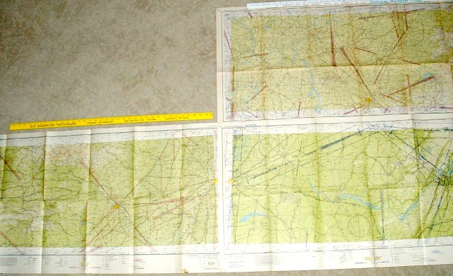
Tactical Maps These maps were used by
infantry and artillery commanders in the field. The coordinates
used in the Operational Reports are based on these maps. The map
sheets were numbered from North to South.
Color: 3 to 5 colors; red, blue used to denote
roads and water.
Size: 24 X 20 inch.
Description of Tactical Maps:
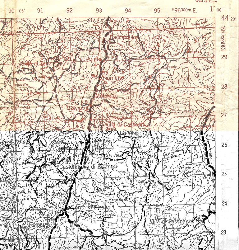
Sheet 89-III - RAVENNA W.-
Bagnacavallo, Mezzano, Fusignano
Sheet 88-I - ARGENTA
- town of Argenta, Hiway 16, Reno River
Sheet 88-II - IMOLA
- Lugo,
Massa Lombarda- Dated Feb 1945
[Reverse side is CANCELED map of Postumia, Sheet 40B-1,
dated 1945. Border of Italy & Yugoslavia- Cerknica, Rakek]
Sheet 88-III - CASTEL S. PIETRO
DELL'EMILLA - Medicina, Hiway 9
Sheet 77-IV
- ARIANO NEL POLESINE - town and Po River & Valle Giralda
Sheet 87-I
- CASTEL MAGGIORE - northern half of Bologna,
S. Giogio di Piano
(This map adjoins the photo-map 87-II
NW, below)
Sheet 105 - LUCCA - Bivouac
for 328FA in December 1944. Scale 1:100,000
Sheet 111 - LIVORNO - Map is
mostly ocean including port, "Leghorn". 1:100,000
Sheet 113 - S. CASCIANO in VAL Di
PESA - Scale 1:100,000
Sheet 49 -
VERONA - Scale 1:100,000
More Tactical Maps:
These maps were bought as a set and were trimmed and
taped to form two larger maps. Some are annotated; one is
hand-colored to show topography.
Sheet 88-III
- CASTEL S. PIETRO DELL'EMILLA 1:50,000
Sheet 87-II
- BOLOGNA 1:50,000
Sheet 98-I -
LOIANO
1:50,000
Sheet 88-III SW
- VARIGNANA SUPERIORE
Overprint of rivers 1:25,000
Sheet 87-II NE -
BOLOGNA
1:25,000
Sheet 87-II SE -
??? (Top title cut off)
1:25,000
Sheet 87-II NW - CASELCCHO
DI RENO 1:25,000
Sheet 87-II SW - SASSO
BOLOGNESE 1:25,000
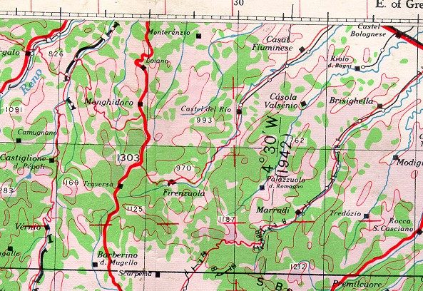
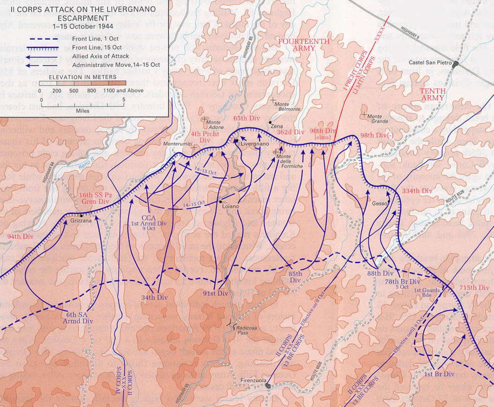
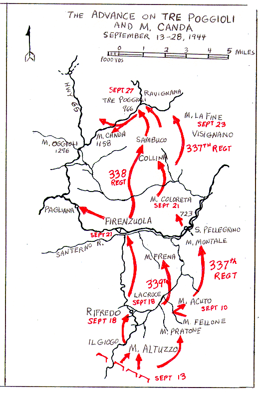
Sheet
98-1 LOIANO – Road and Trail Overlay - This a
medium-scale
map that is a little smaller than the above maps.
Includes
the towns along Hiway 65: Sambuco, Monghidoro, Loiano, and
Livergano(called
“Liver ‘n Onions” by GI’s). These towns were captured by the 91st
Division. Map is marked "Prepared by P.I. Sect. HQ II
Corps”
and “Overprint by 66th Engr. Top. Co., US Army September
1944".
Based on the date, I believe this map was printed after the fighting in
this area for use by support personnel . [See Map II
Corps Attack on Livergano]
Color:
No color. Brown on white paper with roads marked in bold
black.
Scale: 1:50,000 ( 1 inch = 1,388 yards or 1cm = 549
yds)
1 grid is 2cm square.
Size: 22 x 20 inch (effective width is about 17
inches due to wide margin).
Dated: 14 September 1944.
Marked "Reproduced by 66 Engr. Co. (Top)".
Sheet
117-1 S.E. Agugliano - An example of a small-scale map
used
in the field. Very detailed with symbols for all types of
terrain,
roads and structures. This one is of an area just west of coastal town
of Ancona. Map is marked "Revised by 514 Corps Fd. Svy.
Coy.
R.E. Mar 1944" and "Reprodued by 12
Polish
Corps Fd. Svy. Coy. Apr.
1944".
I believe this is the area that the Polish troops passed through.
This is
the SouthEast quadrant from a larger 1:50,000 scale map Sheet
117-1.
Color: Blue Oceans, Red roads.
Scale: 1:200,000 (1 inch = 3.16 Miles)
Size: 24 X 20 inch.
Dated: 1944.
Sheet
150 ROMA & Sheet 136 TUSCANIA - Two maps purchased
from a collection of Polish II Corps archival maps. These appear
to be more of the print style used by the British. One is marked
"46 Survey. Coy. S.A.E.C. Mar.
1944".
I believe this is the area that the Polish troops passed through.
Sheet 150 includes Rome and area East and SouthEast.
Sheet 136 has portion of Lake di Bolsena
in upper right and Montalto di Castro in lower left.
Color: Blue water, Red topographical lines & roads.
Scale: 1:100,000
Size: 24 X 20 inch.
Dated: 1943 & 1944.
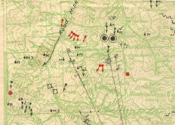
Intelligence Maps -
Bologna & Varignana Superiore - Some
maps were printed with intelligence data showing German
positions. Usually a regular map was printed in one color, green
or light blue and the enemy positions were over-printed in red or
sometimes black. The map would be dated in margins to show
relevance of intel data.
Sheet 87-II NE -
BOLOGNA - Dated
March 1945 1:25,000
Sheet 88-III SW - VARIGNANA
SUPERIORE "Marked Co. M, 337 Infantry"
1:25,000
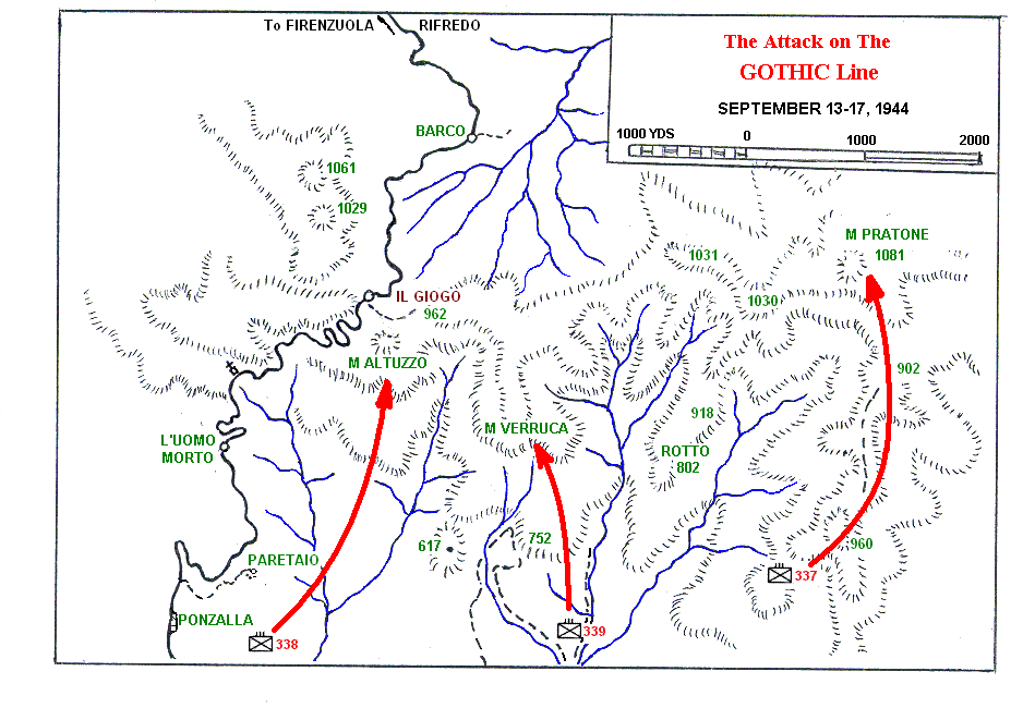
The Gothic Line
- German defenses along the
GOTHIC Line 1:100,000
Defense of Futa Pass
- Details of above map for
area around Futa Pass 1:10,000
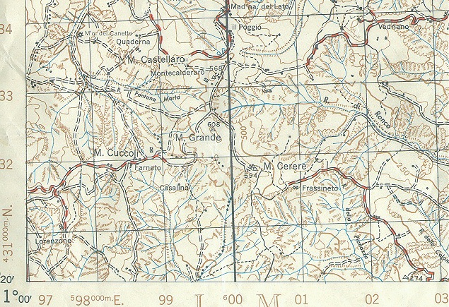
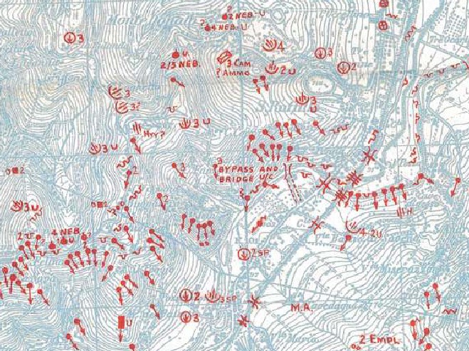
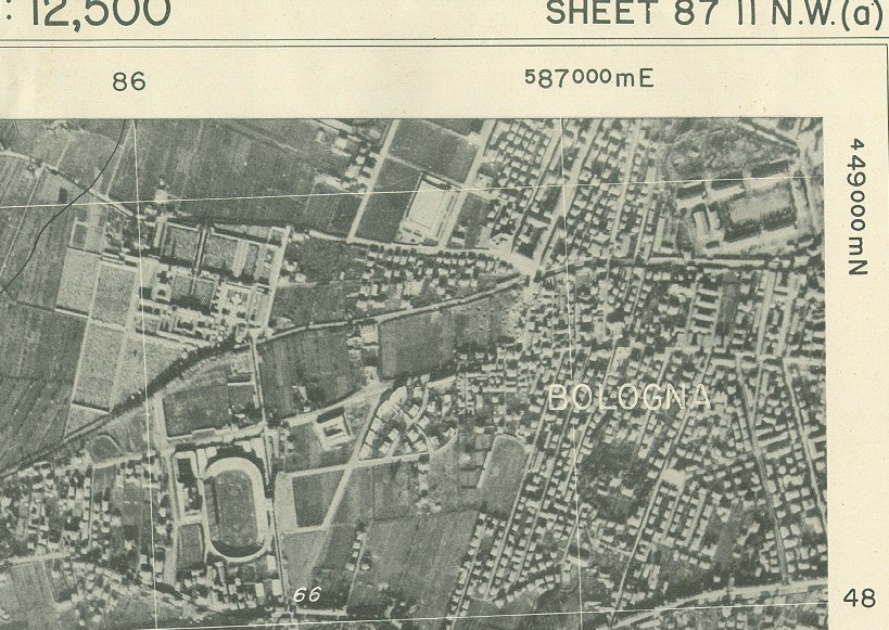
Photo-Maps -
Bologna & Mantova - Sheets 87-II & -III and Sheet 62-II
& -III
Amazing detailed maps made from aerial
photographs. Grid
lines and coordinates are super-imposed using the same coordinate system. These are a little difficult to visualize the
elevations but it has some excellent details of buildings, bridges and
bomb damage. A collection of
maps that include (a) eight
of Sheets 87-II & 87-III of southern half of
Bologna and Hiway 64 and (b) seven of Sheets 62-II & 62-III of Mantova, just south
of Verona .
Color: None--Photo print, overlayed with black & white
details.
Scale: 1:12,500 (1 inch = 694 yds)
Size: 22.5 X 20 inch.
Dated: February, March April, 1945.
Stamped on back: Army Maps Service
Library & ID and date.
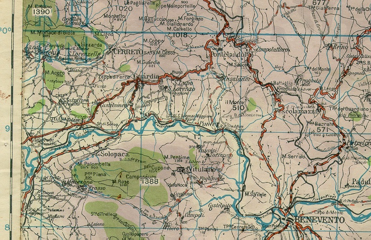
Road
Map of West Central Italy - Army Road Map subtitled "Principal
Roads,
Showing Fifth Army Route Numbering" and marked "Prepared by Engr. Sect.
HQ Fifth Army, 25 Jan. 1944". Simple map with only
towns,
roads and route numbers. Map covers local area near Rome, from Naples
east
to Benevento and north to Carsoli. Cheap map probably issued to
all
truck drivers. Obtained from a American owner who
noted
on container that map was found on a German prisoner.
Color: No color.
Scale: 1 inch = 5 miles
Size: 20 X 13-3/4 inch.
Dated: 1944.
Sheet
36 Benevento
- A colorful map that appears to be British but matches the same
type
above. Map includes area around Benevento and Luccera, and has a
small
portion of Salerno and Naples bay at the bottom. This map is
printed
with letters for map sections and some elevations are printed in a
white box. First printed by
Geographical Section, General Staff, War Office 1941.
Color:
Green for terrain & purple for elevation, blue for water.
Scale: 1:250,000
Size: 24 X 16 inch. Map is not square: 17high X
13 wide.
Dated: 1943.
Bolzano N.E. 46/10 Color Map - A unique and
colorful British map that has color similar to the above but the scale
is smaller. Includes
Trento, Bolzano and as far north as Munich and
Salzburg. Interesting feature is that on the back of this map is
another map and the legend; the map is a CANCELED map
of TOULOUSE
(France) and has a bright red X
printed across it. I have another example of this map that is
attached to a cloth backing..
Color: Full color topography with purple and greens.
Printed both sides.
Scale: 1:50,000 ((1 inch = 1,388 yards
or 1cm = 549
yds)
Size: 34 X 26 inch.
Dated: 1943. Marked EUROPE (AIR)
Cloth
Escape Map of Italy - "AAF Cloth Map - Mediterranean
Series".
Rayon "silk" map was used by flight crews in case they were shot
down.
One side is identified as "No. 4 Tyrol"
and includes Italy and parts of Yugoslavia, Hungary and
Czechoslavakia.
Other side is identified as "No. 6 Balkans"
and covers the Balkans area.
Color: Blue ocean & roads.
Size: 25 X 20 inches.
Scale: 1:200,000
Dated: Sept. 1943.
For detailed description of all AAF cloth maps,
refer to external link www.silkmap.com .
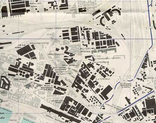
Town Plan of Naples - Two
Maps of Naples,
prepared by British Royal Engineers. Major roads & building
complexes,
such as hospital, factories, etc. are named but streets are not
identified.
"Reproduced by 19 Field Survey Coy, R.E. Nov 1944". Usually you
find these maps
printed on two sheets with eastern half of Naples on one sheet and
western half on
another; maybe to save printing cost.
Color: Blue ocean & roads. City is shaded grey, large
buildings
are black.
Size: 35 X 25 inches, each half of the city
Scale: 1:10,000 (1 inch = 833 feet or 1 cm =
100meters)
Dated: 1944 (corrected), July 1943.
Town Plan of Florence (Firenze)-
A similiar map as above with good details of Florence. Also
have a 16 X 12 inch map issued by the 5th Army Rest Camp that is
printed with post card images of famous buildings of the city. It
has legend of the sites and was issued to enlisted servicemen as a tour
guide.
Color: Blue ocean & roads. City is shaded grey, large
buildings
are black.
Size: 30 X 25 inches.
Scale: 1:10,000 (1 inch = 833 feet or 1 cm =
100meters)
Dated: 1924 (penciled date of Oct. 14, 1944).
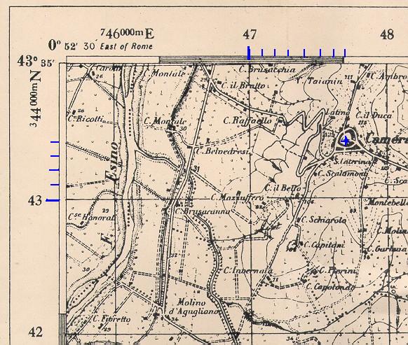
RAF Map Series - A set of air navigational
maps
were issued by the British for use by the Royal Air Force. I was
told that this series had 14 maps in the set and probably covered all
of
Italy and Corsica and maybe more. I only have 4 of the
series.
Marked "1:500,000 Europe (Air)". The maps are identified by a
name
and number of the lattitude and longitude of the lower left-hand corner.
Color: Terrain elevation is noted by pink to purple. Green
forrest, Blue ocean & Red roads.
Size: 34 X 25 inches.
Scale 1:500,000 (1in = 7.9 miles or 1cm = 500m)
Marked: "Complied and drawn at the War Office 1941. Heligraphed at
Ordnance
Survey 1942".
Dated: 1942.
Back is marked: "F/O J T Wann";
an RAF Flight Officer .
Each map is numbered in pencil. The official name is in quotes,
below.
Description
of RAF Maps (Each map is numbered in
pencil
on the back)
No. 11 - "Nice NE 42/6" - Corsica, La Spezia, Italy & coast
of
France that included Nice & Marseille.
No. 12 - "Firenze
(Florence) NE 42/10" - Starts just north of Rome and ends just south of
Bologna.
No. 13 - "Roma NE 40/10" - West coast, Rome, Naples, 2/3 of
map is sea.
No. 14 - "Napoli NE 40/14" - West coast with Naples &
Salernao;
east coast is most of "heel".
|

